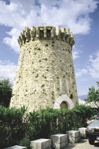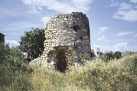

 At the other end of the mountain range of Irta, about five km away from Peñíscola, the Almadum tower, from 1554 (Peñíscola, Baix Maestrat). |
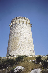
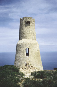 El Gerro or L’Aigua Dolça Tower (Denia, Marina Septentrional). One of the most beautiful towers on the Valencia coast, strengthened by a lower solid body that characterises it. |
|
|
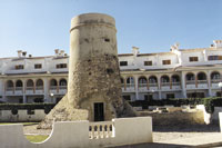
The coastline is probably the portion of the Valencian soil that has changed the most in the last decades. And not only from the aesthetic point of view, but also in relation to the collective imagery. Well into de 20th century, the perception of the Valencian coastline still didn’t differ so much from that that oozed from the military books of the early 17th century: “…because the seaside, although in a way it makes a kingdom or a province strong, it also makes it easy for them to be attacked with sea weapons and the defender is kept in much suspense because he doesn’t know where that navy is going”. Only in this way it is understood why they talked about the “deserts” of life in the Valencian coastline at that time: “the sixteen leagues of desert there are from Alicante to Cartagena” or “the desert there is from Castellón to Peñíscola”, very different from today’s appreciation of this coastline. Beyond the specific cause of danger —at first corsairs, some decades ago illnesses, the rocky or little fertile land of creeks, cliffs, swamps and marshes—, the twofold consideration of hope and threat, richness and danger was solved, until a few decades ago, in favour of the first elements in the pairs. Born out of this perception and very real experiences, some human interventions over the coastal environment, which tended to reduce that danger, were taken to term. One of these led to the shaping of a prototypical circum-Mediterranean landscape— not only Valencian—: what we can call the defense landscape, the watchtowers by the seashores. Somebody defined landscape as the inventory of human actions over an area. From this point of view, the oldest human intervention in the Valencian coastline as such can be considered to be the creation of a general system of defense, rooted in the knowledge of the physic features of the coastal environment and aimed at altering the adverse natural conditions for mankind, until its reduction to an acceptable level, subordinated and, at last, fully dominated. This happened in the mid 16th century, when the thought of art dominating nature arose. However, in order to intervene over the territory, it was necessary to know it first. And that was what some of Philip II’s engineers did. It is highly possible that, for the first time, one of those men noticed the presence of different landscape units in the Valencian coastline: long, open and fine-grain sand beaches; shadowy creeks, enclosed by forested cliffs and high escarpments, marshes and impracticable swamps… From this reconnaissance and the application of the subsequent architecture, of engineering and the art of war many reports of action arose. And, in fact, the presence of a tower over a hillock, over a cape, by the bank of a river, in the middle of a beach or over a cliff, can be seen by the contemporary observer not only as the child of a especially turbulent historic period or as another element of the artistic heritage, but as the key for the interpretation of the physical landscape that surrounds it. The presence of a tower is never gratuitous, or left to chance. In this case, geography is decisive. Or nearly, because, on top of it, we would have to imagine the historic situation of a country divided by an internal border that marked the presence of pockets of Moorish population in vast interior areas. Giovanni Baptista Antonelli, in 1563, and Juan de Acuña, in 1585, among others, read the Valencian coastline regarding the situation at that time. The observed it as a whole for the first time, but also as the addition of different local landscapes. As a whole they judged it to be dangerous, difficult, but also strategic (“because abandoning the coastline is not defending the kingdom”). And in fact, they, and others like themselves, proposed a system of hierarchical global defense. Maybe at that time this defense system was the only administrative structure that, from the Sènia River to the Segura River, was under the same flag for the whole kingdom. It was under the Habsburg coat of arms (sub umbra tuarum alarum protegem can be read under the two-headed eagle that protects the shield of four bars in the Tower of El Gerro de Denia). But, also for the first time, the reading of the landscape is also detailed and meticulous. At one point in history, reports speak against this area, nowadays saturated by tourists who now long for those landscapes that were rejected in the past. Of the South of the country reports say: “one has to notice that the coastline that goes from the landmark between the kingdoms of Valencia and Murcia up to the town of Xàbia is the most dangerous part of the coast of the kingdom of Valencia (…) and of this part, the most dangerous part (…) is from the town of Calpe to the tower of Cabo Primo and Cabo Martín” and of the North: “the most dangerous part of the coastline of the kingdom of Valencia is towards the East (…) is from the tower of Grao de Morvedre up to the vicinity of tower of Oropesa”. At the same time, they knew that in order to protect the twelve kilometres of coast dominated by the marsh of Prat de Cabanes or the fifteen kilometres that reached the beach at El Puig and Sagunt only one or two towers were needed. There, human danger was averted by Nature. On this reading of the landscape, we have yet more things detailed. Water was —is, and will be— essential in the Mediterranean. For each river, for each fresh water spring, for each lagoon inlet, the construction of a tower was proposed so as to prevent corsairs from using them. This was a key to the system. And so it happens with the mouth of the Segura River, and also in the river of Altea, in the river of Molinell, in the river of Gandia, in the river of Millars, in the springs of Alcossebre. And if it was not possible to build a tower, it was recommended to block the creeks with stones so as to hinder access, as in Estanyó, Pardines and del Lleny creek, close to Guardamar, or in the hill of Aguiló, in La Vila Joiosa. On this thristy coastline, another factor shows to be of importance: protection against the frenetic elements of Nature. In a coast like the one in Valencia, lacking big natural ports, except for the one in Denia, any salient crag in the coast, any small cliff surrounded by the sea, any creek protected from eastern and northern winds, were spaces that had to be defended. And the reporters of Phillip II knew this. This is the reason for the towers in the creeks of Genovés, Guardamar (“ships can be sheltered when escaping from enemies or from the wind”), Coveta Fumada, Granadella, Illeta (El Campello) or in the Moraira bay. Besides, they had the experience of the corsair attacks. The corsair Dragut had disembarked at the mouth of the Sec River in order to devastate the farmland in Alicante. The lagoon inlets in Elche and Alicante had been used by the moors to set foot on the land. When the moors attacked La Vila Joiosa they did so by disembarking in the beach of Gitalei and everybody knew that the creeks in Benidorm were the perfect place to find corsair galleys or that the corner of Jaedor, in Les Penyes del Albir, was a “stronghold of enemies”. The Algerian captains also knew their geography! Sometimes, the towers weren’t there to hinder the entrance to the creeks, but to block the exit. The fortification in Cabo Negret, near to Altea, had to block that “quay of new Christians to Algiers”, and also had the tower at the beach in Piles. The kingdom of Valencia was, from the 13th century, a frontier land. But, together with the internal border, there was a newer and more extensive one— the coastline. Thus we can understand those military reports that speak of Guardamar as the “border” of Orihuela, and of Xàbia, Oliva and La Vila Joiosa as the border of Denia, Alicante and the port of Elche. From the meticulous observation of the natural conditions of the coastline —both locally and globally—, and the situation of the immediate territory, was born a complete and intertwined system of coastal defense. In 1563, there had already been built 43 towers and in 1585, they were 52. Nine defensive zones, subordinated by the authority of the officers who followed regulations of the year 1554 and 1673, compartmentalised the Valencian coastline with geographic logic. From the South to the North, natural elements used to form the limits between areas. The lower Segura River and the Vinalopó were defensive zones separated by the Segura River. From the town of Alicante up to the Crag of Ifach there was a third defensive zone, leaving the whole of the Marina Septentrional, the fourth zone, as a closed subsystem, coherent with the geographic conditions of the area. The whole strip of coastal plains, from the landmark of Denia and the one of Castellón, was divided in four zones, and Oliva, the Albufera of Valencia and the maritime quarter of Sagunt were their internal limits. From the mountain range of El Desert de les Palmes up to Sòl de Riu was the last zone, unitary, “protégée” of the one of Prat de Cabanes — here, towers surrounded the marsh in the inside, in solid ground and were “private” fortified country houses—, and by the mountain range of Irta, and only from Peñíscola to Vinarós was the coast defended with towers and fortifications once again. The absence of Moorish population in this area lowered the psychological pressure. The spatial logic of the system even made it possible to try out the “geographic” classification of the watchtowers. Broadly speaking, its distribution could be as follows: 1. Towers located in creeks and cliffs. Of the 55 we have recorded, twenty were at some height above the sea level, in order to defend a creek suitable for disembarking or hide and to control a portion of sea. Among the clearest examples it is necessary to mention the tower of Alamdum (Peñíscola), of Sant Benet (Alcalà de Xivert), of Colomera (Oropesa), of the Cullera cape, of La Bombarda (L’Alfàs del Pi) or of Caletes (Benidorm). 2. Towers located by jets of fresh water, assigned for the supply for enemies. They are more than a dozen and all of the rivers of the country remained under their control, as well as other places of less importance. From the North to the South: the Sénia river, the Les Coves or Sant Miquel river, the Millars river, the Sec river, the Belcaire river, the Palancia river, the Xúquer river, the Girona river, the gully of the Gort, the Altea river, the Montenegre river and the Aigües gully had a tower built in their mouths. Moreover, the Cérvol river (in Vinarós), the Alcalà water course (in Benicarló). The Guadalaviar River (with the bastion of the maritime quarter in Valencia), the El Perelló inlet in the Albufera of Valencia (with La Casa del Rei), the river in Xeraco, the water in Piles, the Gorgos river (with Xàbia and the castle of Fontana), the De la Vila river (with La Vila Joiosa) and the Segura river (with Guardamar). 3. Towers over low beaches, near villages or populated areas, assigned to the protection of quays or ports and the access roads to the inland. They are generally squared fortifications, stronger, like the tower of Sal (Cabanes), of El Rei (Grao de Castellón), of Grao de Morvedre, of La Valldigna or of Grao de Gandia. 4. Towers with a communicative function and in control of the immediate coast by means of “atajadores” —soldiers either on horse or on foot that covered with their walks a part of the coastline. They are no more than ten and are located at low height, over low cliffs or at the beach, but without a populated area or town to defend, like the ones in the Irta cape, in the El Puig cape (Horta), el Pinet cape (Elche), Roig cape and the Foradada cape (both of them in Orihuela). They were the links in a chain. To sum up, as Fernand Braudel pointed out, sometimes geography can, like history, give an answer to many questions. If those Valencian people form the 16th century built the defense landscape, now it is our turn to defend that landscape from another threat, who knows if worse than the one that triggered those interventions on the coastline environment. Josep Vicent Boira Maiques. Department of Geography. University of Valencia. |
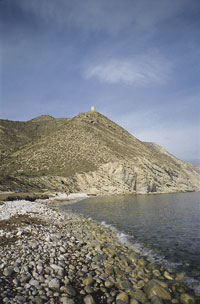
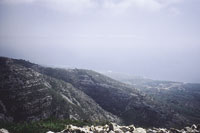
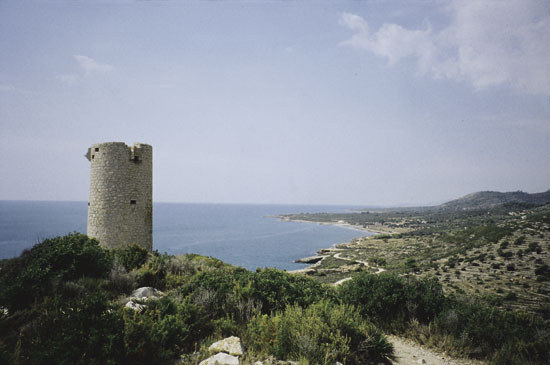
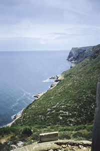 The San Antonio cape from the El Gerro tower. The beginning of an area with not too many towers. With cliffs, nobody was able to penetrate it.
|