
How much warmer is the Mediterranean becoming?
Thirty-five years of satellite observations
Global warming particularly affects the oceans and seas. In the Mediterranean Sea, in situ oceanographic and meteorological records, together with the most recent satellite observations, show an estimated warming of between 0.6 °C and 1 °C over the last three decades. In this article we present the results of an analysis of a 35-year series of monthly thermal images in the western basins of the Mediterranean. The data indicate an intensification in the summer season: with the summers becoming longer and more intense and the months of June and July recording the highest rates of warming, with increases of 0.6 °C/decade.
Keywords: Mediterranean, global warming, climate change, physical geography, remote sensing.
The Mediterranean, a «miniature ocean»
The Mediterranean, a semi-enclosed sea framed by three continents, is a unique setting. It occupies only 0.7 % of the world’s ocean surface and 0.3 % of its volume of water, but is considered by many authors as a «miniature ocean», a perfect laboratory for studying climate and hydrological patterns (Bethoux et al., 1999), because many phenomena observed in the oceans also take place in the Mediterranean. The configuration of its basin, which has large topographical contrasts, and its intermediate position between temperate and subtropical climates make this sea a particularly sensitive area and it has, therefore, been identified as a climate change hotspot.
«The Mediterranean is a particularly sensitive area, identified as a climate change hotspot»
The Mediterranean can be defined as a «concentration basin» where water losses through evaporation (outputs) exceed gains (inputs) from rainfall and rivers. This deficit is compensated by the exchange of marine waters of different salinity with the Atlantic Ocean through the Strait of Gibraltar and, to a lesser extent, with the Black Sea through the Bosporus narrows. Less dense Atlantic water flows through Gibraltar and progresses towards the eastern basin, changing as it flows through; at greater depths, denser Mediterranean water flows out of the eastern part of the basin.
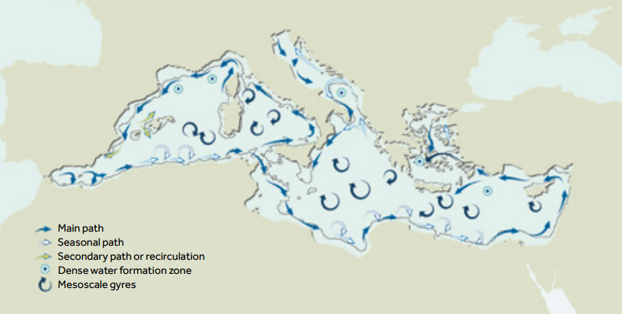
Figure 1. Map of the surface circulation patterns in the Mediterranean (according to Millot & Taupier-Letage, 2005). General circulation in the Mediterranean originates from the differences in density between the different water masses. It is structured in three layers (surface, intermediate, and deep) and shows a cyclonic pattern around the western and eastern sub-basins. / Source: UN Environmental Programme. GRID-Arendal.
The general pattern of circulation, first described at the beginning of the twentieth century, is thermohaline,1 i.e., it originates from the differences in density between the different bodies of water. It is structured in three layers (surface, intermediate, and deep) and follows a cyclonic pattern around the western and eastern sub-basins (Figure 1). The Mediterranean is also one of the few places in the mid-latitudes where deep water formation occurs. This is a fundamental process of oxygenation of the deep layers of water which takes place in winter in the Gulf of Lion and the northern Adriatic. In recent decades, the general circulation pattern initially described has been revised and some characteristics of mesoscale circulation and elements of inter-annual variability have been incorporated in the light of increasingly extensive observations and measurements (Bergamasco & Malanotte-Rizzoli, 2010; Millot & Taupier-Letage, 2005).
«The main environmental problems we have identified in the Mediterranean are related to the climate and hydrology of the basin itself»
River inputs are a relevant factor in the hydrological balance of the basin. Only six basins cover an area of more than 50,000 km2 (those of the Nile, Rhone, Ebro, Po, Moulouya, and Evros) and fifteen others cover 10,000 km2 each; the rest are small and medium sized, with a short-lived torrential system. The torrential nature of the rivers and the Mediterranean climate, characterised by episodes of heavy rain, often produce floods that have a major impact on human societies. In recent decades, there has been a decrease in river contributions to the basin, partly as a result of climatic causes, but mainly due to human activity, such as the construction of reservoirs and an increase in agricultural consumption. The decrease in river contributions may be one of the factors that could explain the recent increase in the salinity of the deep Mediterranean waters (García-Martínez et al., 2018).
The main environmental problems we have identified in the Mediterranean basin are directly or indirectly related to the climate and hydrology of the basin itself: the scarcity of water resources, frequency of flooding because of the intensification of extreme rainfall, erosion and coastal degradation processes, water pollution from urban and industrial discharges, and forest fires. Human pressure on the shores of the Mediterranean – which has been more intense in recent decades – has ignored the fact that the Mediterranean Sea is an environmental system in which multiple factors interact; any alteration entails impacts on global functioning whose consequences we are far from being able to assess.
Recent warming of oceans and seas
Today, there is a consensus in the scientific community regarding global warming due to the increase in atmospheric CO2, which has been particularly evident over the past four decades. The Fifth Assessment Report (AR5) of the Intergovernmental Panel on Climate Change (IPCC) reported a global warming of 0.85 ℃ for the period 1889–2012 (IPCC, 2013). On a global scale, it has been estimated that between 1970 and 2010, the oceans had accumulated more than 90 % of the energy increase in the climate system. Global warming is evident in the surface layer, up to 75 m deep, where an average rate of thermal increase of 0.11 ℃/decade has been reported.
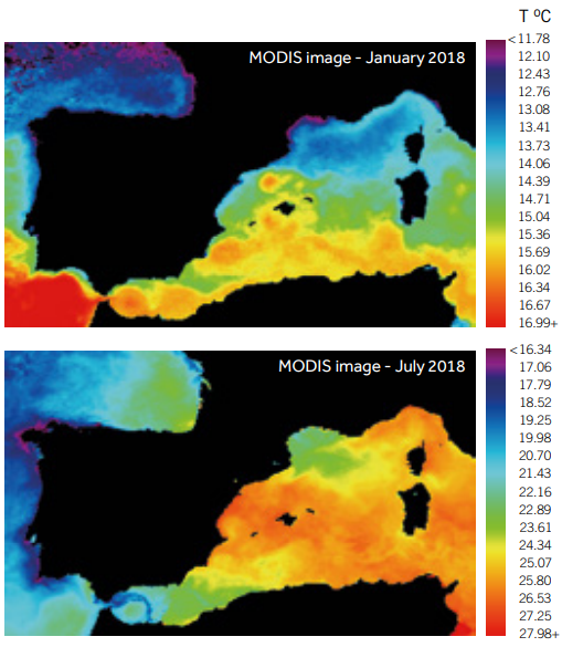
Figure 2. Example of a typical winter (January 2018) and summer (July 2018) scenario for the temperature of Mediterranean waters. In winter, a north-south latitudinal gradient (~4 °C) was observed between the coldest waters in the northern basin and the warmest ones in the Alboran basin. In summer, the spatial temperature variability was greater (~9 °C) and there was a high degree of warming in the central basins. The image shows the area analysed. / Source: Pictures by NASA EOSDIS PO.DAAC processed by the author.
It is not easy to identify temporal trends in marine ecosystems that can be used to assess the impact that environmental changes, including climate change, are having on them. The paucity of in situ records from marine stations and oceanographic campaigns over long time series, as well as differences in the instrumentation and methodology used in data collection, make retrospective analyses difficult. The measured rates vary depending on the spatial scale (global, regional, or local), area analysed, and time period considered.
Based on the sea surface temperature (SST) databases compiled at the Hadley Centre in the United Kingdom Meteorological Office, several authors identified a period of temperature decline between 1948 and 1970, followed by a continued period of accelerated warming since then (Belkin, 2009; Trenberth et al., 2007). According to these authors, the surface temperature in the Mediterranean increased by 0.71 ℃ from 1982 to 2006, making this sea one of the areas of the planet classified as «rapidly warming» (together with the Baltic Sea, North Sea, Sea of Japan, and Sea of China), with rates that are 2–4 times that of the global average.
Moreover, recent reports by the Copernicus Marine Environmental Monitoring Service (CMEMS) based on available (in situ and satellite) observations (Von Schuckmann et al., 2018), point to a global oceanic warming of 0.016 ℃/year since 1993, with much higher figures for the Mediterranean (0.04 ℃/year).
«Human pressure on the shores of the Mediterranean has never considered the fact that the sea is an environmental system in which multiple factors interact»
In the Iberian Mediterranean, as well as the intermediate and deep layers, there is no doubt about the increase in surface temperature and salinity. The latest Cambio climático en el Mediterráneo español report (“Climate change in the Spanish Mediterranean”, Vargas-Yánez et al., 2010) showed an average increase in sea surface temperature for the period 1948–2005 which fluctuated between 0 ℃ and 0.5 ℃, depending on the area of the Mediterranean coast considered; at intermediate depths (200–600 m) the increase was between 0.05 ℃ and 0.2 ℃ and in the deep layers, it was between 0.03 ℃ and 0.1 ℃. Although the increase in the deep layers may seem minor, given the high specific heat of the sea, small increases mean that the sea has absorbed enormous amounts of heat. This warming was particularly noticeable from the 1970s onwards.
Systematic maritime observation records in the Iberian Mediterranean were mostly implemented in the 1990s, with the exception of the L’Estartit Oceanographic Station. This station (located on the Catalan continental platform, 4 km from the coast) covers the longest uninterrupted oceanographic series in the Mediterranean because it has been recording data since the 1970s. Based on these observations, Salat, Pascual, Flexas, Chin, and Vazquez-Cuervo (2019) reported a warming rate of 0.03 ℃/year in the surface layers, with higher values (0.09 ℃/year) recorded for the last decade. The same authors also identified seasonal variations, with higher rates recorded in spring (0.039 ℃/year).
What do the observation satellites tell us about the Mediterranean?
Since the 1980s, thermal images obtained by the Advanced Very High-Resolution Radiometer (AVHRR) sensor on board NOAA satellites have provided a synoptic and continuous view that complements in situ recordings. The radiation recorded by these sensors is considered representative of the sea surface temperature, a key parameter in climate studies. Over time, other sensors have been incorporated, such as the Moderate Resolution Imaging Spectroradiometer (MODIS), which allows the sea surface temperature and other oceanographic parameters to be accurately inferred.
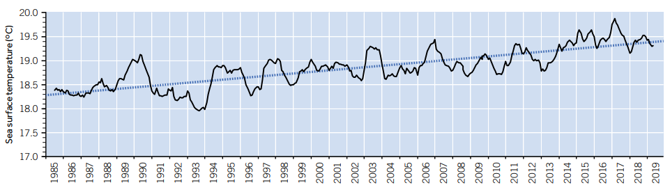
Figure 3. Evolution of sea surface temperature in the Ligurian-Provençal, Balearic, Algerian, and Alboran basins for the period 1985–2019, from thermal images from the NOAA and MODIS satellites. The average heating rate was 0.03 °C/year.
At the beginning of remote sensing from space in Spain, the PhD dissertation La temperatura del mar Balear a partir de imágenes de satélite (“The temperature of the Balearic Sea from satellite images”) (López García, 1991), the product of a collaboration between the Department of Geography and the Remote Sensing Group in the Department of Thermodynamics at the University of Valencia, showed the potential of thermal images to gain a better understanding of the hydrology of the Mediterranean and marked the beginning of the research presented here. Thirty years later – with the images having been extensively proved as viable – the availability of image series of sufficient quality and extension and the possibility of contrasting the results with data obtained by other authors, have allowed us to confirm the trends pointed out in previous publications (López García, 2015; López García & Camarasa, 2011). An updated summary of this research is presented below.
«There is a growing consensus that warming is not a future projection but an obvious reality»
Various studies (López García & Camarasa, 2011; Mohamed et al., 2019; Nykjaer, 2009; Shaltout & Omstedt, 2014; Skliris et al., 2012) based on satellite data have suggested warming rates in the Mediterranean ranging from 0.015 to 0.04 ℃/year, depending on the region and period considered. The highest values (0.05 ℃/year) were identified in the eastern Mediterranean. In summary, we can say that over the last three decades the Mediterranean Sea has experienced an estimated increase in its global surface temperature of 0.6–1 ℃. Some predictions based on these data, and considering the trends of recent years, suggest that this increase could reach 5.8 ℃ by 2100 (Sakalli, 2017).
Focusing on the Ligurian-Provençal, Balearic, Algerian, and Alboran basins of the western Mediterranean, our analysis covered the series of monthly thermal images available from January 1985 to October 2019.2
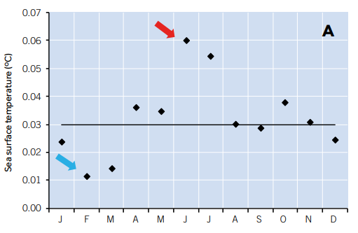
Figure 4. Graph A represents the rates of change (°C/year) in sea surface temperature (SST) calculated by month. The lowest values occured in winter (February and March) and the highest ones were recorded in spring-summer (June and July). The horizontal line marks the average annual rate (0.03 °C/year). All the trends were significant (with p-values ranging from < 0.0001 to 0.034) except for February, which was not statistically significant.
The average seasonal curve obtained for this series and for the area as a whole shows that the lowest monthly rate was in February (14 ℃) and the highest in August (25 ℃). However, in some years (August 2003, September 2009, and August 2018) monthly values above 28 ℃ were recorded at some points in the basin. As an example, Figure 2 shows the spatial variability of temperatures in winter and summer in the different sub-basins. In the typical winter scenario there was a clear latitudinal gradient with colder waters in the Ligurian-Provençal basin and warmer waters in the Alboran basin. The summer situation was characterised by warming of the central basins (Balearic and Algerian) while the waters with an Atlantic influence in the Alboran were always comparatively colder.
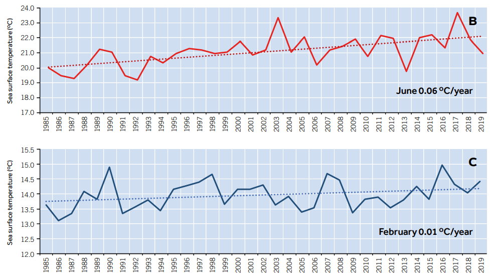
Figure 4. Charts B and C represent the time adjustments for the months of June and February.
The recent warming of the Mediterranean is evident from the evolution curve obtained for 1985–2019 (Figure 3) which represents the average temperature calculated for all the basins in each month with a 12-month moving average applied to filter out the seasonal effect. The resulting rate of variation for all the basins was 0.03 ℃/year, which represents a total temperature increase of approximately 1 ℃ over the decades considered in this analysis.
Longer, warmer summers
The calculation of monthly heating rates showed seasonal differences ranging from minimum values in winter (~0.01 ℃/year in February and March) to maximum values in spring-summer (~0.06 ℃/year in June and July) (Figure 4).
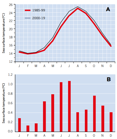
Figura 5. A) Average seasonal curves of the surface temperature of the Mediterranean for the periods 1985–1999 and 2000–2019. B) Temperature increase per month between both periods. The changes in the seasonal curve show that the summer season was starting earlier and becoming longer, with temperature increases of 1 °C during the summer and 0.5 °C in the autumn between both periods.
These data confirm previously published results (López García, 2015) indicating that warming in the Mediterranean occurs mainly during the spring–summer months, which therefore entails changes in the seasonal curve. While the warming of the sea over the last 35 years is estimated to have been approximately 1 ℃, this increase mainly occurred during the months of June and July when the temperature rose by almost 2 ℃.
The variations in the seasonal curve can be seen more clearly in Figure 5, which shows the average seasonal curves calculated for the periods 1985–1999 and 2000–2019, together with the monthly temperature increases between both periods in absolute values. In the first decade (1985–1999), the 24 ℃ average was only exceeded in August, while in recent decades (2000–2019) this occurred in three months (July, August, and September), with monthly averages close to 27 ℃ recorded in August 2003 and 2018. These results show that the summer season started earlier and was more intense, with average temperature increases in spring–summer (~1 ℃) and autumn (~0.7 ℃) over the last two decades.
Conclusion
The analysis carried out in the western Mediterranean basins shows that rapid warming has occurred over the last three decades, with an average rate of 0.03 ℃/year, which was even higher depending on the Mediterranean region analysed. These figures are in line with those recently published by other authors and confirm the trends noted in previous studies referring to the 1985–2009 period (López García, 2015). Warming in the Iberian Mediterranean took place mainly in spring–summer and autumn, and there was a clear trend towards the anticipation, prolongation, and intensification of the summers.
The consequences of warming in the Mediterranean (Figure 6) in terms of rising sea levels, potential alteration of marine circulation patterns, the abundance, distribution, and structure of marine species, and the frequency and intensification of atmospheric processes such as isolated high altitude depressions, are matters of interest and research for the scientific community, as shown by the IPCC Special Report on the Ocean and Cryosphere in a Changing Climate (25 September 2019). While the causality and attribution of these consequences to climate change remain difficult to discern, there is a growing consensus that warming is not a future projection but an obvious reality.
We must reflect upon the role of human beings as the main agents of this warming, but also on our responsibility for the many processes that have altered on the shores of the Mediterranean and in the sea itself: the excessive urbanisation of the coast and alteration of natural coastal ecosystems, agricultural intensification, overexploitation of aquifers, river and marine pollution, and overfishing, among other actions, have impacted and accelerated effects that should not be attributed solely to sea warming. Thus, there is a need for greater awareness and the implementation of immediate actions to slow down and mitigate the environmental problems we are facing.
Notes
1. The term thermohaline refers to the temperature and salinity of water masses, which determines their density. (Go back)
2. For the 1985–2009 period, the NOAA-AVHRR satellite images from the Pathfinder archive of the Physical Oceanography Distributed Active Archive Center (PO.DAAC) v.5 were used; the 2000–2019 period used images from the MODIS-Terra Level 3 v2014 sensor. In both cases, we analysed night-time images with a spatial resolution of 4 km that had been corrected by algorithms tested and validated by NASA. These data are available online at the Jet Propulsion Laboratory (NASA). The availability of data from both sources for the period 2000–2009 and their high correlation (r2= 0.99) allowed the series to be homogenised (López García, 2020). (Go back)
References
Belkin, I. (2009). Rapid warming of large marine ecosystems. Progress in Oceanography, 81(1–4), 207–213. https://doi.org/10.1016/j.pocean.2009.04.011
Bergamasco, A., & Malanotte-Rizzoli, P. (2010). The circulation of the Mediterranean Sea: A historical review of experimental investigations. Advances in Oceanography and Limnology, 1(1), 11–28. https://doi.org/10.1080/19475721.2010.491656
Bethoux, J. P., Gentili, B., Morin, P., Nicolas, E., Pierre, C., & Ruiz-Pino, D. (1999). The Mediterranean Sea: A miniature ocean for climatic and environmental studies and a key for the climatic functioning of the North Atlantic. Progress in Oceanography, 44(1–3), 131–146. https://doi.org/10.1016/S0079-6611(99)00023-3
García-Martínez, M. C., Vargas-Yáñez, M., Moya, F., Zunino, P., & Bautista, B. (2018). The effects of climate change and rivers damming in the Mediterranean Sea during the twentieth century. International Journal of Environmental Sciences & Natural Resources, 8(4), 555741. https://doi.org/10.19080/IJESNR.2018.08.555741
IPCC. (2013). Climate change 2013: The physical science basis. Contribution of working group I to the Fifth assessment report of the intergovernmental panel on climate change. Cambridge University Press.
López García, M. J. (1991). La temperatura superficial del mar Balear a partir de imágenes de satélite (dissertation). University of Valencia, Spain.
López García, M. J. (2015). Recent warming in the Balearic Sea and Spanish Mediterranean coast. Towards an earlier and longer summer. Atmósfera, 28(3), 149–160. https://doi.org/10.20937/ATM.2015.28.03.01
López García, M. J. (2020). SST Comparison of AVHRR and MODIS Time Series in the Western Mediterranean Sea. Remote Sensing, 12(14), 2241. https://doi.org/10.3390/rs12142241
López García, M. J., & Camarasa, A. M. (2011). Recent trends of SST in the Western Mediterranean basins from AVHRR Pathfinder data (1985-2007). Global Planetary Change, 78(3-4), 127–136. https://doi.org/10.1016/j.gloplacha.2011.06.001
Millot, C., & Taupier-Letage, I. (2005). Circulation in the Mediterranean Sea. In A. Saliot (Ed.), The Mediterranean Sea. Handbook of environmental chemistry (vol. 5K, pp. 29–66). Springer. https://doi.org/10.1007/b107143
Mohamed, B., Abdallah, A. M., El-Din, K. A., Nagy, H., & Shaltout, M. (2019). Inter-annual variability and trends of sea level and sea surface temperature in the Mediterranean Sea over the last 25 years. Pure Applied Geophysics, 176(8), 3787–3810. https://doi.org/10.1007/s00024-019-02223-2
Nykjaer, L. (2009). Mediterranean Sea surface warming 1985-2006. Climate Research, 39, 11–17. https://doi.org/10.3354/cr00794
Sakalli, A. (2017). Sea surface temperature change in the Mediterranean Sea under climate change: A linear model for simulation of the sea surface temperature up to 2100. Applied Ecology and Environmental Research, 15(1), 707–716. https://doi.org/10.15666/aeer/1501_707716
Salat, J., Pascual, J., Flexas, M., Chin, T. M., & Vazquez-Cuervo, J. (2019). Forty-five years of oceanographic and meteorological observations at a costal station in the NW Mediterranean: A ground truth for satellite observations. Ocean Dynamics, 69, 1067–1084. https://doi.org/10.1007/s10236-019-01285-z
Shaltout, M., & Omstedt, A. (2014). Recent sea surface temperature trends and future scenarios for the Mediterranean Sea. Oceanologica, 56(3), 411–443. https://doi.org/10.5697/oc.56-3.411
Skliris, N., Sofianos, S., Gkanasos, A., Mantziafou, A., Vervatis, V., Axaopoulos, P., & Lascaratos, A. (2012). Decadal scale variability of sea surface temperature in the Mediterranean Sea in relation to atmospheric variability. Ocean Dynamics, 62, 13–20. https://doi.org/10.1007/s10236-011-0493-5
Trenberth, K. E., Jones, P. D., Ambenje, P., Bojariu, R., Easterling, D., Tank, A. K., Parker, D., Rahimzadeh, F., Renwick, J. A., Rusticucci, M., Soden, B., … Zhai, P. (2007). Observations: Surface and Atmospheric Climate Change. In S. Solomon, D. Qin, M. Manning, Z. Chen, M. Marquis, K. B. Averyt, M. Tignor, & H. L. Miller (Eds.), Climate change 2007: The physical science basis (pp. 235–336). Cambridge University Press.
Vargas-Yáñez, M., García, M. C., Moya, F., Tel, E., Parrilla, G., Plaza, F., Lavín, A., & García, M. J. (2010). Cambio climático en el Mediterráneo español. Temas de Oceanografía, 3 (2ª ed.). Instituto Español de Oceanografía y Ministerio de Ciencia e Innovación.
Von Schuckmann, K., Le Traon, P. Y., Smith, N., Pascual, A., Brasseur, P., Fennel, K. & Djavidnia, S. (Eds). (2018). Copernicus marine service ocean state report. Journal of Operational Oceanography, 11(sup1), S1–S142. https://doi.org/10.1080/1755876X.2018.1489208
Acknowledgements
All the satellite images used in this research were provided, free of charge, by NASA through the Earth Science Data and Information System (ESDIS) and the Physical Oceanography Distributed Active Archive Center (PO.DAAC) at the Jet Propulsion Laboratory, Pasadena, CA (USA). The author is grateful for the data provided and the technical assistance received.