Mallorca’s Caves and Coves
The genetic and hidrological relationship between coves and caves
The exploration and documentation of the coastal caves in Migjorn, Mallorca –many of which have large underwater galleries– would suggest a genetic and hydrological relationship between these coves and endokarst. These caves are an essential part of Mallorca’s natural heritage.
To begin with we should point out, as Rosselló stated (2005), that if we move from the toponymic –or popular– ambit to the scientific one, not all coves are calas (coves) strictly speaking, nor all those called so. On the one hand, authors such as Gràcia et al. (2011) deduced from the collapse of the roof of a cave forming a more or less narrow and long kind of inlet called a caló. On the other hand, many coastal cavities are related to seawater flooding of varying proportions. Rosselló et al. (2002) discuss the complexity at the average scale of the east coast of Mallorca and southern Menorca, precisely by the concurrence of coves and caves in Upper Miocene limestone, which are very sensitive to karst-driven evolution. The coves are associated with the mouths of river courses, but their shapes may have been affected by subsidence, driven by fracture and karstic dissolution processes that have occurred at different levels.
Coastal notches in Migdia de Mallorca
Notches and hollows generated by coastal erosion processes, namely caves related to marine abrasion, abound along the coast, although they are often rather modest in size. Moreover, the most important coastal karst cavities belong to the type of caves in the coastal mixing zone. Indeed, these are the type appealing to travellers and naturalists, especially following explorations carried out for over a century in the tourist attraction Coves del Drac, namely «Dragon’s caves», in the Manacor municipality. In recent decades, a genetic model has been put forward for these caves, which considers the formation of primordial voids, caused by dissolution in the water table due to the aggressiveness of the mixture of fresh inland waters and marine waters within highly permeable rock, given significant primary porosity. Many of the galleries and chambers forming these cavities are now located below sea level and have been invaded by water. It is very interesting that there are different levels of cavities, corresponding to different periods of speleogenesis. The planimetric pattern of caves like these would indicate the somewhat random coalescence of more or less independent units, which have grown three-dimensionally, connecting with each other to give rise to a branching formation.
«Coastal karst cavities are the type appealing to travellers and naturalists, especially following explorations carried out in the Coves del Drac»
Besides the aforementioned caves resulting from marine abrasion –non-karst– a type of cavity abounds on the coast, which is the result of the caves being captured within the coastal mixing zone, namely, karstic processes, due to the eating away of cliffs by sea-driven mechanical erosion. Given the combination of processes, these caves are known as karstic-marine captures. Quite complex sedimentary deposits abound, which are interspersed by speleothems (mineral deposits) with ossiferous deposits of terrestrial vertebrates and marine detritus, which provide chronological records of great interest. These deposits depend entirely on Quaternary variations in sea level, due to glacio-eustatic factors. The current Mediterranean sea level is also a factor determining the existence of underground lakes of brackish groundwater, which fill lower reaches of the caves.
During the Pleistocene, glacio-eustatic sea level declines precipitated the collapse of cave walls and vaults, while later extreme phases of speleothem deposition contributed to masking the characteristics of primeval cavities and collapsed matter. It should be noted that the magnitude of the rock fall and mechanical alteration of the rock mass largely determines the appearance of most galleries and cavities, while also being responsible for the formation of exterior openings due to surface subsidence. In Mallorca these formations are known as abisaments in the Manacor region and esfondrats in Ses Salines. Meanwhile other galleries, usually found in less permeable rock dating to the Upper Miocene, are hardly affected by subsidence and here water corrosion morphology dominates, as in the case of external lagoon facies.
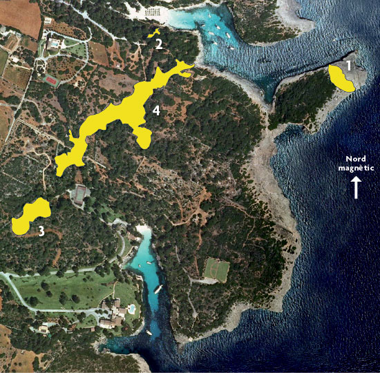
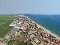
The Felanitx region (Mallorca) has a very rugged coastline, forming many bays and headlands, like Cala Sa Nau, which opens onto a 100-metre gorge and Cala Mitjana. Yellow indicates the location of the underwater cave in Cala sa Nau (1), the Ses Barraques cave (2), Cala Mitjana cave (3) and En Bassol cave (4). / Grup Nord de Mallorca.
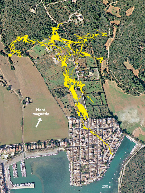
The dolços (submarine springs) found in many coves and harbours in Mallorca are another example of the crosstalk between karst and sea. The picture shows the Es Coll cave in Portocolom (Felanitx), a 7-kilometre-long formation found on a bend of the Es Rivetó. / Grup Nord de Mallorca
The play between coves and littoral caves
In Manacor harbour, the Genovesa cave is just over a hundred metres from the sea at the end of the Cala Anguila beach. The cove mouth measures 140 m in width, and it is 250 m in length (main polygonal axis of the cove) with an average width of 95 m. The cavity, a cave in the coastal mixing zone, runs 2,415 m and penetrates just over 500 inland, measuring from the beach. Although a degree of protection is afforded by its classification as an EU landmark of community interest and as a site of cultural interest by the Council of Mallorca, wastewater from the villegiatura pours directly into the cavity. This is a good example of how coastal fragility is facing the onslaught of coastal urbanisation, not only on the surface but also below ground with the pollution of groundwater and –via drainage– of the sea.
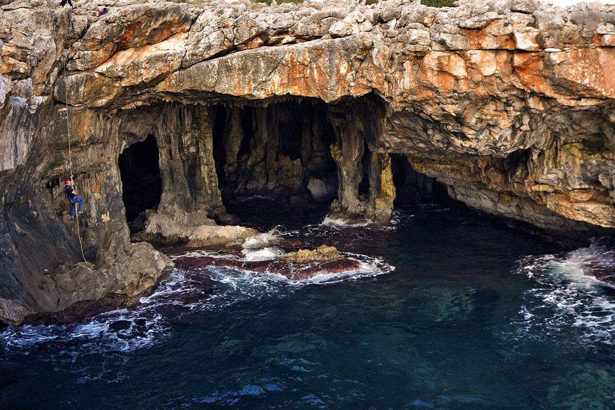
The cave known as Cova del Pilar, also on Manacor coast, is a cave of great beauty with its grand entrance and large columns or pillars, covered with blue seaweed stirred up by the waves during bad weather, visible from ships sailing along the coast. It is a good example of karstic-marine capture with large speleothems that are eaten away by erosion wrought by waves, and is a paradigmatic example of the sea penetrating inland as the cavity recedes. At present, the sea inlet, besides the roof of the cave, measures about 40 m, but the sea goes further inland and could reach almost another 50 metres.
«In addition to the beautiful lakes, Es Coloms cave is notable for the presence of marine sands at the bottom of a large dry gallery»
Further south is Falcó cove, 300 m wide and 175 m long. It presents several karstic-marine captures of considerable importance, such as the Es Coloms cave in Falcó cove and the Cala Falcó cave, along with other associated cavities. The Cala Falcó cave is believed to be related to the well-known Pirata-Pont-Piqueta underground system, measuring 3,091 m in length, which less than 200 m away and runs 700 m inland. The subsidence of ancient galleries has separated this cave from the endokarstic system. Moreover, the encroachment of Es Coloms cave by the sea has visibly shifted the line of cliffs inland, and left layers of quaternary loamy sediments hanging on the sea cliff, which cling to the walls of the huge sea inlet. In addition to the beautiful lakes, this cave is notable for the presence of marine sands at the bottom of a large dry gallery.
Just a short distance away and heading south, still within the Manacor region, we find Cala Varques. The mouth measures some 200 m in width, 320 in length and is an average of 160 m wide. The caves lining the cove shoreline and in direct or near contact with the sea are: Cala Varques B cave, Cala Varques ACD or Es Xuetes cave, Es Genet cave, Es Coloms cave in Cala Varques or the Es Coloms II cave and the Marina de Pont cave. Of all these, the Cala Varques B cave is the largest, running 1,068 m and with a maximum depth below sea level of more than 30 m. Its location, at the back of the beach, is an indication of how the cave and Varques cove might eventually evolve in the event that the roof of the gallery, which is located at an altitude much below sea level, collapses.
In Felanitx harbour, the cave known as Cova Gran, is a large hollow cavity formed by marine abrasion, which has retreated over 70 m with respect to the coastline and whose entire roof is susceptible to collapsing and forming a recess measuring more than 120 m. This has forced the change of urban planning near the cave.
Cala Sa Nau and Cala Mitjana are located between Portocolom and Cala Herrera, although closer to the latter, and about 5 km from the town of S’Horta. They are part of the Felanitx bay, lined by Neogene calcareous rock measuring up to 4 km wide. It is a very rugged area of coastline forming many bays and sharp headlands. Cala Sa Nau opens onto a 100-m gorge, measuring 500 m in length and with an average width of 55 m. An outstanding landmark in the area is the En Bassol cavern, located in the coastal mixing zone, lying in a NE-SW direction and measuring 1,491 m in length. It was found by chance during water prospection, and has no natural entrance. The abundance and beauty of the speleothems and the size of the galleries make it a major attraction.
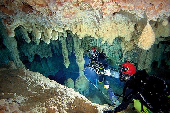
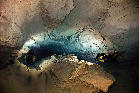
Cavities lining the coastal strip are a valuable natural heritage. Many endemic troglobitic species live in the groundwater. In addition, geomorphological, palaeontological, chronological and aesthetic wealth is very high. / M. A. Perelló. GNM
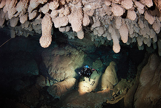
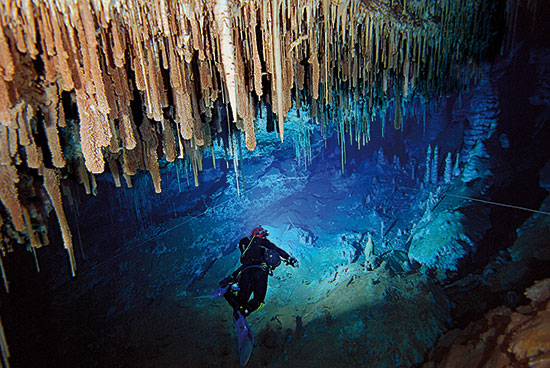
Above, groundwater speleothems (carbonate deposits of precipitation) from the ceiling of the cave Es Drac at Cala Santanyí indicate ancient Mediterranean sea levels. / A. Cirer. GNM
As the caves peter out and the sea encroaches inland, significant changes arise in the cove. In the southeast, where there is a small sea inlet, the cliff seems to have receded and the cove has eaten into En Bassol cave. Currently, marine sedimentation has closed direct communication between the cave and the sea on a human scale, although there is evidence that marine polychaetes and some crustaceans can still get into the cave. Other neighbouring caves are the underwater cave in Cala sa Nau and the Ses Barraques cave. The first is located in a geographical promontory and would pass right through the tip, from one side to the other, were it not for the sedimentation that accumulated during a Quaternary marine regression, blocking one of the entries with eolianite (consolidated dune).
Part of the En Bassol cave runs south, towards Cala Mitjana, which is just 170 m away. The cove mouth measures some 230 m and is 500 m in length, with an average width of 75 m. Just 180 m from the cove is the Cala Mitjana cave, running some 340 m, which was found during water prospection, when a 13-m-deep well was dug in the past. The surface water is used to irrigate a large grassy area, near the sea, which –among other things– currently characterises Cala Mitjana Creek. The situation of El Bassol cave suggests it is part of one system and landfall has rendered it impenetrable and isolated both cavities.
In Cala Santanyí, located in the municipality bearing the same name, we find Es Riu cave, whose mouth is 260 m wide, length is 360 m and average width is 90 m. Es Riu is the sea upwelling of the Es Drac cave in Cala Santanyí, of which it forms part. It is located in the northwest, within a recess of the bay, measuring 27 m wide and 31 long and continues under the water until the accumulation of sand and stone closes off the connection with the rear cavity. It was formerly part of the Es Drac cave in Santanyí cove, an 803-m cavity running 228 m inland with respect to the sea. Due to subsidence and marine sedimentary deposits, it was cut off from the rest, while external subsidence –clearly noticeable in aerial photographs– formed the sea inlet and played a role in the evolution of the creek itself. Moreover, noteworthy are the numerous underwater caves found at the mouth of the cove, where they form a complex of tunnels with abundant entrances and associated forms of marine abrasion. Progressive landfall-driven disintegration of the Es Drac cave in Cala Santanyí, or other underwater caves, favours further sea inlet and encroachment of these spots, greatly affecting the evolution of the cove.
Not only in the east of Mallorca are there genetic relationships among marine cavities and recesses. In Migdia, specifically in the town of Las Salinas, on the Es Dolç beach (near Colonia de Sant Jordi) the Grup Nord de Mallorca team is studying an underwater cavity, discovered in 2011. This unprecedented cave has been created by processes of subsidence and sea erosion, and is known as the Es Dolç pond, as named by Cosme Aguiló. This gulf, penetrating over 40 m, has been formed by the retreat of the cavity and is another example of karstic-marine capture in the coastal mixing zone, in this case composed of more recent matter (from the Pliocene) than in the eastern Mallorca (Miocene).
Above, the sea cave Es Pont in Cala Varques (Manacor) is a good example of karstic-marine capture where there is a clear interaction between karst processes and coastal dynamics. / M. Luque
Submarine springs in coves
Submarine springs, called dolços in Mallorca, are not unique to coves but are commonly associated with them, and are often present in cavities accessible through underwater caving techniques.
Cala Murta, in the Manacor region, has a mouth measuring 100 m in width, is 225 m in length and 45 m average width. The spring wells up on the north side near the bottom of the cove, just a few metres deep, coming from a cavity measuring approximately 100 linear metres. In periods of heavy rains followed by high seas, the upwelling water flows in abundance. In addition to the freshwater drainage infiltration, the decline in sea level under high barometric pressure conditions is a major factor underlying the water flow, which is quite spectacular and gives rise to turbulence that is visible even from the headlands. By contrast, the deposition of marine sediments, especially sand, due to storms and ocean currents, can block the underground conduit. However, when weather conditions change, the water gushes out with such force that it flushes the sand out leaving the gallery empty again. This water source is undoubtedly related to the Es Drac caves, which are just a few metres away. Further south is the Es Coloms cave in Cala Varques, which is genetically related to Genet’s cave and separated by a landfall.
«Submarine springs, called dolços in Mallorca, are not unique to coves but are commonly associated with them»
Then in Portocolom in the Felanitx Marina, we find Es Rivetó, name given to a bend in the harbour that resembles an inland creek. This name is usually associated with underwater springs, like S’Esdolç or Aigo Dolça, located within Es Rivetó. The spring, which issues from dry dock, is the underwater entrance to the cave of Es Coll, an important endocarstic formation measuring 7,090 m in length with strong structural organisation, where permeability associated with the fracture is important in that these materials are significantly less porous than reef deposits found in other parts of Migdia. The barometric changes translate into current output or input, by way of ducts, to compensate for the difference in sea level and groundwater. Thus, when the sea rises due to this direct connection with the cave, the water enters. The opposite phenomenon occurs when the sea level drops, as the water runs out of the cavity searching for hydrostatic equilibrium. An extraordinary event happened in the aftermath of the Algerian earthquake on June 4, 2003 at 18.33, when the sea water withdrew totally, leaving Es Rivetó dry. This phenomenon resulted in incredibly strong currents that arose from Dolç and even dragged the fishing boats that were moored near the slipway.
Cala Sa Nau is 2.5 km to the south, where we have another rivetó place name. The water flows under the sand of the sea bed on the south side of the beach, just over a metre deep. This dolç –freshwater spring– comes from the Ses Barraques cave, very close to the En Bassol cave, and characterises the beach given the significant thermal contrast it creates. In summer, the water leaving the endokarstic system can make a difference in temperature between the sea and groundwater of 6 to 10 °C. Also Es Riu cave in Cala Santanyí was inspired by this place name, corresponding to the freshwater spring from the Es Drac cave in Cala Santanyí.
Blocks accumulated due to the progressive caving in of Genovesa cave, a formation reaching just over a hundred metres from the sea in Cala Anguila Manacor. / A. Cirer. GNM
Dolç is situated in a completely different coastal landscape, without cliffs, like the beaches of Colònia de Sant Jordi (Ses Salines). The beach goes by the same name, due to the lower salinity of the sea and the shocking temperature contrast between sea water and the groundwater that emerges in the Es Dolç pond.
Hidden wealth present in the cavities calls for conservation. The picture shows En Bassol cave (Cala Sa Nau), a cavity without a natural entrance, found by chance during water prospection. / M. A. Perelló. GNM
There are many factors and processes involved in the formation and evolution of coves. The presence of karst cavities captured by marine erosion and then progressively dismantled is an additional factor to consider. In some small coves or inlets making small indentations in the coastline this may have been a determining and almost exclusive factor. Meanwhile, its contribution to the evolution of larger coves and even natural harbours may have been more or less important.
Many freshwater upwellings –known as dolços– come from karst cavities, from which continental waters drain and interact hydrologically with the sea, representing an inland encroachment of the sea.
Acknowledgements Thanks to Toni Cirer and Miquel Àngel Perelló, from Grup Nord de Mallorca, for the underwater photographs and Miquel Àngel Perelló, GNM, and Manolo Luque, GELL, for the aerial photographs. These studies have been carried out over recent years, thanks largely to Obra Social de Sa Nostra funding within Biodiversity Conservation Projects.
Bibliography Aguiló, C., 1991. La toponímia de la costa de Felanitx. Centre cultural de Felanitx. Felanitx. Ginés, J., 2000- El karst litoral en el levante de Mallorca: una aproximación al conocimiento de su morfogénesis y cronología. Tesi doctoral. Departament de Ciències de la Terra. Universitat de les Illes Balears. Inèdita. Gràcia, F. et al., 1997. «Les coves de la zona de ses Partions-Portocolom (Felanitx, Mallorca)». Endins, 21: 5-36. Gràcia, F. et al., 2011. «Cavitats subaquàtiques de la franja litoral de Mallorca». Endins, 35: 103-132. Rosselló, V. M., 2005. «Cala, una mesoforma litoral: concepte, models i aproximació morfomètrica». Cuadernos de Geografía, 77: 1-18. Rosselló, V. M. et al., 2002. «El papel del karst en el macromodelado litoral: el ejemplo de las cales de las Islas Baleares». In Carrasco, F. et al. (eds.). Karst and Environment. Patronato de la Cueva de Nerja. Màlaga.